

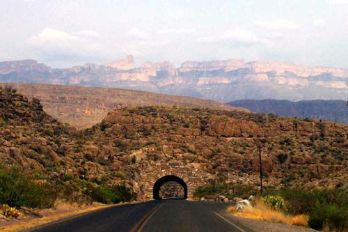
 TUNNEL TO TWO COUNTRIES: This passageway through a mountainside was just about a little less than two miles for where I’m camping out. (If you follow up from the left side of the tunnel to the top of the photo, you'll see one peak jutting upward. That's El Pico, and it's a full mile up in the sky: to the left of that point is U.S. territory, to the right is Mexico.)
The views along the way were stunning as the buttes, mesas and mountains rose up out of the desert. But the highest of the peaks are shrouded in moisture somehow rising off the desert floor. More than magnificent, but no good for pictures
I passed several of the cars from the Open Road Race dashing in the opposite direction after finishing the race and swinging west from Sanderson through Marathon and then north back to Fort Stockton. Legend has it that there is very little law “West of the Pecos.” I don't know about that, but this I can assure you: there’s definitely no speed limit.
Those same folks who told me to stock up at Fort Stockton laughed when I suggested Marathon, which is much closer to the park. Stopping there, I found a southwestern artist community.But it sure seems to me that Marathon could only host those artists with very wealthy patrons: after filling up with $3.13-a-gallon gas, I tooled down the small strip, passing by several galleries, to a general store where a case of water was priced at just under $19.
Just south of Marathon, about three or four miles, I passed a U.S. Border Patrol Station. Though I traveled by fences and gates for many ranches along the route, along with some small oil wells with holding tanks, that was the last true building I was to see until I reached the park gate.
I purchased a yearlong National Parks Pass at the gate, which I hope to give a good workout too. It was 26 miles more to the Park Welcome Center at Panther Junction. Most national park welcome centers have some stuffed animals or photo exhibits of park denizens. Not this one. Nope! This one featured dinosaur fossils recovered here at the park, one a hellacious-looking piece of jawbone, with thick teeth about three-or-four inches long.
As I had heard in San Antonio about horseback tours of the park, I inquired about this at the welcome center. The ranger gave me a pamphlet for a ranch which hosts these tours, but it is located in Lajitas, outside the park on its western edge. Looks to be about 45-50 miles away from where I am camping. Disappointed for now, I'll have to make due with the majestic views, exploring the edges of the Rio Grande (which defines the southern border of the park for 118 miles), some short hikes and lots of great photo opportunities. I will be passing by the horse ranch on my way west out of here and will re-assess the situation then.
Another 21 miles down the winding road to the river’s edge and I finally settled in at my camping spot in Rio Grande Village. Along the way I passed some incredible vistas. I hope that the moisture burns off in the next couple of days so I'll have some photos to share. I’ll be here at least four days, so I have mountain-high expectations.
* * *
A personal revelation: I’m a sucker for cactuses. As a kid, I had about 10 of them at different times. Somehow, I was able to kill them all - some, it seems, with too much attention, others with too little. Even the ones that you never touch or water; they too died. Can’t explain it. (And please don’t ask about my aquarium; it’s way too painful to talk about.) Anyway, this place is full to the brim with cacti, all different types, sizes and colors (!). I’m going to take a lot of pictures of cactuses. A lot!
* * *
There is no cell phone service at this end of the park, and spotty service just about anywhere else nearby. The ranger put me onto a spot high up on a turnout on the other side of the tunnel (see above) where I might catch a signal and be able to file some posts. I headed over and up there, but still had no signal bars. After cruising around the lower east of the park, searching for a signal, I returned back to the trailer to discover that someone in one of the several quarter-million dollar RV rigs which pulled in today has a wireless-satellite setup I was able to leech onto. It’s a weak signal, but I’ve got one word for it - Hallelujah!
No comments:
Post a Comment